Driving the San Juan Skyway
236-mile scenic loop through southwestern Colorado
Connects Ouray, Silverton, Durango, Cortez, Telluride, and Ridgway
Elevation ranges from about 6,000 to over 11,000 feet
Can be driven clockwise or counterclockwise
Full loop driving time approximately 6–7 hours without stops
Includes multiple high mountain passes and scenic byways
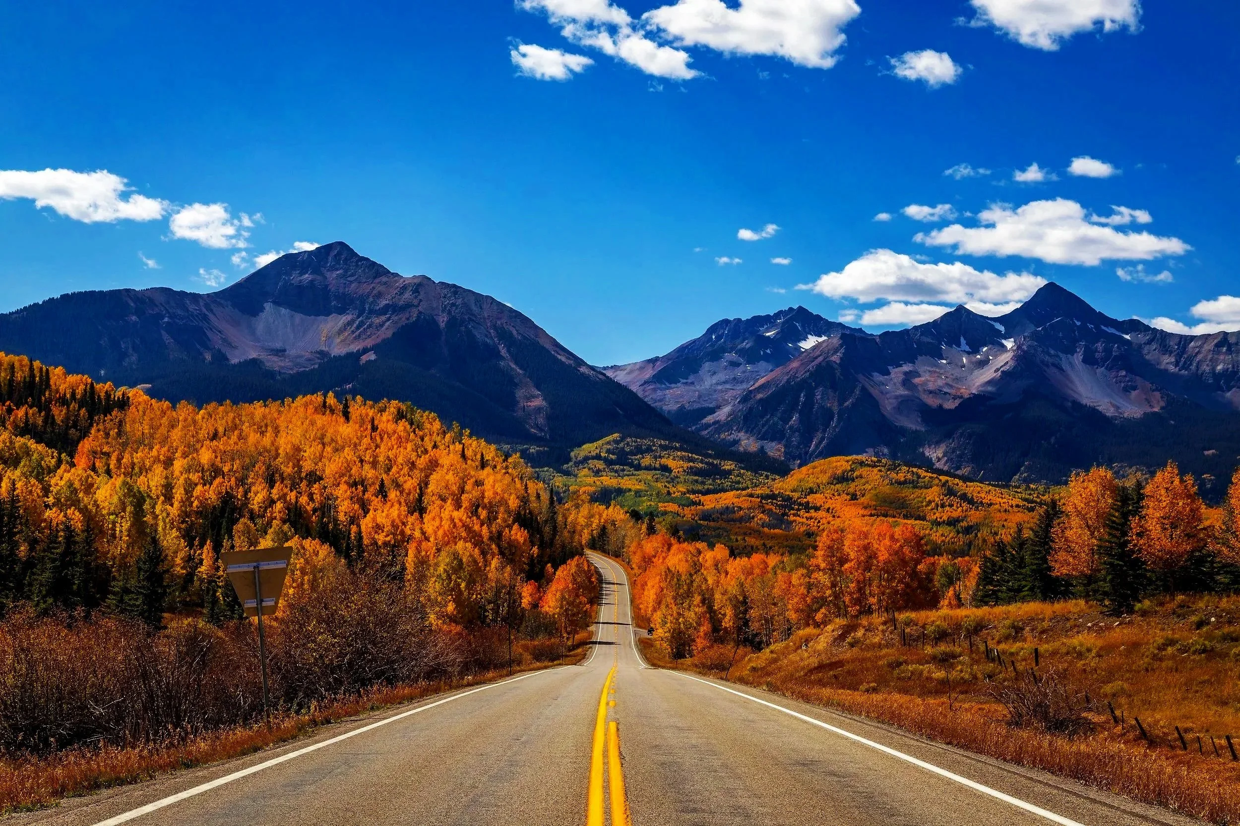
Traverses alpine, forest, valley, and desert landscapes
Designated Colorado Scenic Byway and U.S. All-American Road
QUICK FACTS
The San Juan Skyway forms a 236-mile scenic loop through southwestern Colorado, connecting historic mining towns, alpine passes, agricultural valleys, and red rock canyon landscapes along one of the most spectacular driving routes in the Rocky Mountains. Unlike a typical point-to-point highway, the Skyway functions as a continuous circuit that travelers may enter from multiple gateway communities and experience in either direction. While the full loop can technically be driven in a single day, the region’s dramatic elevation changes, scenic overlooks, historic districts, and outdoor recreation opportunities encourage a slower and more immersive journey. Travelers who allow time to explore the landscapes and communities along the route discover that the Skyway offers far more than a simple mountain drive—it provides a window into the geography, history, and culture of Colorado’s San Juan Mountains.
Understanding the Loop
The San Juan Skyway connects communities that each represent distinct landscapes and historical traditions within southwestern Colorado. As the route circles the San Juan Mountains, travelers pass through alpine terrain, forested valleys, agricultural basins, and high desert transitions.
Key Communities Along the Loop
Ridgway – Northern gateway in the Uncompahgre Valley, often used by travelers arriving from Montrose and northern Colorado
Ouray – A dramatic mountain town set within a steep box canyon near the Million Dollar Highway
Silverton – Historic mining town surrounded by alpine peaks and former mining districts
Durango – Regional hub with rail heritage, historic downtown, and access to southern mountain terrain
Cortez – Gateway to the Four Corners region and nearby archaeological landscapes such as Mesa Verde
Telluride – Former mining town now known for its mountain setting, ski terrain, and cultural events
Because the Skyway forms a loop, travelers may begin from any of these communities depending on route access and itinerary. (Related page: [The Five Drive Segments of the Skyway] – Geographic breakdown of the full loop system.)
Choosing a Direction
The San Juan Skyway can be driven clockwise or counterclockwise. Both directions offer exceptional scenery, but the visual perspective changes with orientation.
Many travelers choose a counterclockwise route beginning near Ridgway or Ouray. This places some of the more exposed roadway segments closer to the mountain side in key sections of the Million Dollar Highway.
Clockwise travel provides broader outward views across valleys and basins when descending from alpine passes.
Both directions are fully navigable when driven attentively. Direction choice typically depends on comfort with mountain driving, photographic preference, and starting location.
(Related page: Safety and Mountain Driving Fundamentals – Core driving practices for high-elevation roads.)
Drive Time Expectations
Under continuous travel, the full loop requires approximately 6–7 hours of driving time. However, this does not reflect typical visitor experience. Additional time is commonly added for:
Scenic pullouts and overlooks
Photography stops
Historic downtown exploration
Museums and cultural sites
Weather variation at high elevations
Wildlife activity along rural sections
Most travelers benefit from 1–3 days to fully experience the route at a relaxed pace.
(Related page: Suggested Itineraries (1-Day, 2-Day, 3-Day) – Planning options for different travel styles.)
Elevation and Weather Variability
The Skyway ranges from roughly 6,000 feet in valley floors to over 11,000 feet at mountain passes. These elevation shifts create rapid and sometimes dramatic weather changes within short distances.
Travelers may encounter:
Warm valley conditions
Afternoon thunderstorms in alpine zones
Fog or wind at high passes
Snow at elevation while lower areas remain dry
Flexibility and awareness of forecasts are essential when traveling through higher sections of the route.
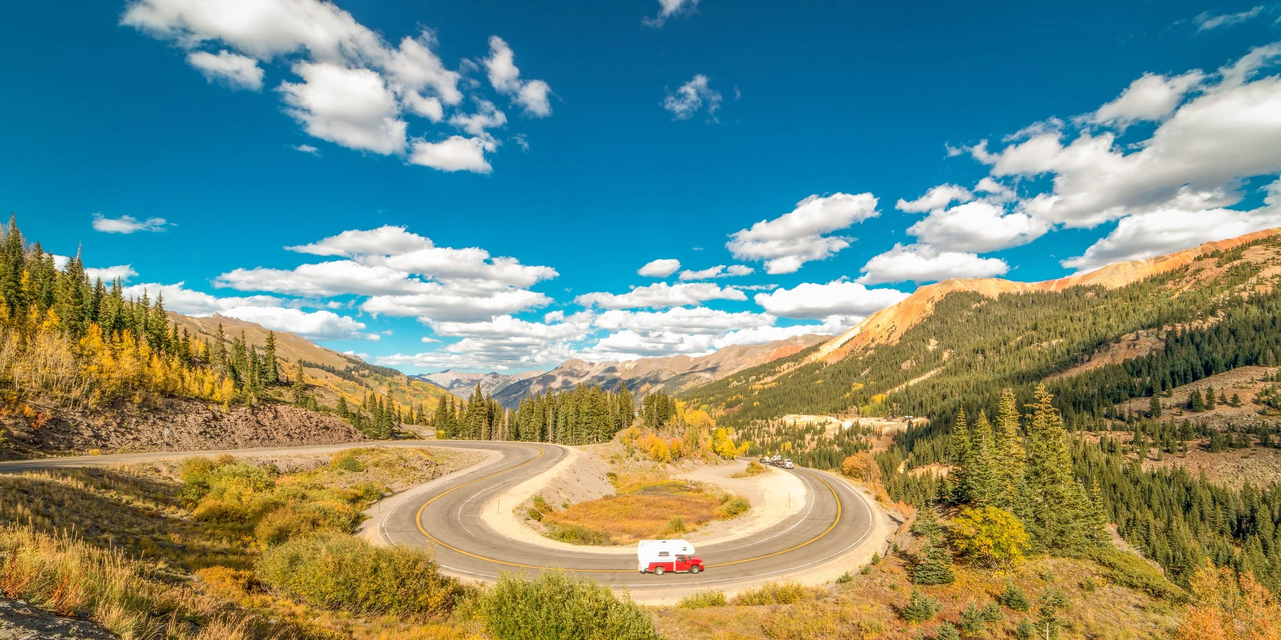
Regional Example: Million Dollar Highway (Ouray to Silverton)
Elevation: approximately 7,800 to over 11,000 feet
One of the most recognized segments of the San Juan Skyway is the stretch between Ouray and Silverton, commonly known as the Million Dollar Highway. This section climbs through steep terrain with sweeping views of rugged peaks, deep valleys, and historic mining districts.
Sharp curves, narrow lanes, and high-elevation exposure make this segment both visually striking and technically demanding. Scenic pullouts provide opportunities to safely experience the surrounding alpine landscape.
(Related page: Driving Conditions and Safety – Guidance for steep grades, curves, and high-altitude driving.)
Why This Topic Matters
Driving the San Juan Skyway is more than travel between destinations—it is a continuous experience shaped by geography, history, and elevation. Understanding the loop helps travelers:
Navigate safely through changing mountain environments
Plan realistically for time and distance
Appreciate historic towns and landscapes more fully
Engage responsibly with high-alpine terrain
CONTINUE EXPLORING (Skyway System Cluster)
The Five Drive Segments of the Skyway – Breakdown of the loop into distinct geographic sections
Suggested Itineraries (1-Day, 2-Day, 3-Day) – Structured trip planning for different schedules
Fuel, Services, and Elevation Planning – Where and how to plan stops along the route
RV and Motorcycle Considerations – Guidance for larger vehicles and two-wheel travel in mountain terrain
Best Scenic Segments by Season – How the Skyway changes visually throughout the year
Safety and Mountain Driving Fundamentals – Core driving practices for high-elevation roads
Return to San Juan Skyway Home Page
ADDITIONAL TOPICS ACROSS THE SAN JUAN SKYWAY
Climate, Seasons, and When to Visit
Volcanic Origins of the San Juan Mountains
[Chicago Basin and the Needle Mountains] Coming Soon

A scenic section of the San Juan Skyway showing the winding mountain roadway and panoramic views of the San Juan Mountains. The image illustrates the diverse terrain and elevations encountered along Colorado’s 236-mile alpine loop.
If you want the complete experience in one place, the San Juan Skyway becomes most meaningful when viewed as a connected system of landscapes, geology, and history.
→ Go Deeper: The Complete San Juan Skyway Guidebook
The San Juan Skyway: Into the Heart of the Colorado Rockies
Want the full Journey?